
History of the Land of Fox Valley Estates
Uncovering history is an ongoing process, so as new information is presented this page is inevitably going to change.
Summary
To summarize the history of the land of Fox Valley Estates:
- In the "Original Land Grants" of Maryland, the land of Fox Valley Estates was once a part of "Dorsey's Grove", a tract of land purchased originally (as far as the research has taken us) by John Dorsey who "took up Dorsey's Grove in upper Howard, 1080 acres, extending from Glenelg to Glenwood." (quote from "The Founders of Anne Arundel and Howard Counties, Maryland"). This land was then divided among his children and continuously divided from there.
- This land was once owned by Enoch Selby. Not sure about how the transfer happened between the families, but there were several marriages of Selbys and Dorseys which may or may not have been a factor.
- Fox Valley Estates was once the post office location and center of the town of Ivory, Maryland. The post office also contained a general store and was owned by William Sheppard (grandson-in-law of Enoch Selby). The name Ivory came from Ivory soap!
- Prior to the development of Fox Valley, this neighborhood consisted of one road - West Ivory Road - and off of West Ivory Road were three homes and two 100 acre farms.
Details and Research
The first evidence we have for the history of this land comes from old maps. By overlaying maps and matching roads (primarily the current Folly Quarter and Triadelphia Roads which have been in existence for quite a long time, as well as the towns of Glenelg and West Friendship) we can see what was once in this area. Please note that although care was taken to overlay maps accurately, it is likely that it's not perfectly lined up just due to differences in the maps (the older ones done with older technology may not be perfectly accurate, and also roads and locations of the towns may have slightly shifted since then).
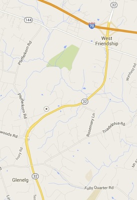
The map we are going to use as "current day" was a section of our area from Google Maps. On this map there is marker at the intersection of West Ivory Road and Fox Valley Drive, the approximate center of our neighborhood. This map intentionally includes that towns and road we listed above and are using as markers.
The map we are going to use as "current day" was a section of our area from Google Maps. On this map there is marker at the intersection of West Ivory Road and Fox Valley Drive, the approximate center of our neighborhood. This map intentionally includes that towns and road we listed above and are using as markers.
Dorsey's Grove
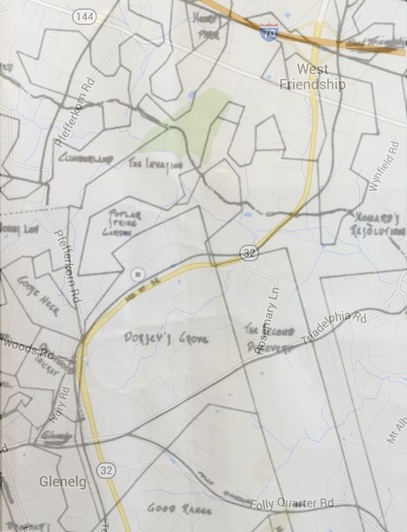
This map overlays the "current day" map above with that of the "Original Land Grants of Howard County, Maryland". The "Original Land Grants" shows all 359 of the County's original land grants. These were the grants given out after "Charles I of England granted the original charter for Maryland to Cecilous Calvert, the second Lord Baltimore, in 1632. The Calverts recruited Catholic aristocrats and Protestant settlers from England, in part by offering them generous land grants. The largest land grant, 7,000 acres, was called Doughregan and was patented by Charles Carroll in 1702. The smallest was the one acre Find It If You Can, which was patented by Charles Welsh in 1767. May patentees gave their grant fanciful names, including Kings Contrivance, Bachelor's Choice, Ranter's Ridge, Lost by Neglect, Break Neck Hill, Long Reach, and Chews Vineyard, some of which have become names of Columbia's villages." (quote taken from the Howard County Historical Society's Book "Howard County".)
From these two overlaid maps we can see that this area that is now Fox Valley was a part of primarily "Dorsey's Grove" and also a little bit of "The Invasion" and "Poplar Spring Garden".
"Dorsey's Grove", a tract of land purchased originally (as far as the research has taken us) by John Dorsey who "took up Dorsey's Grove in upper Howard, 1080 acres, extending from Glenelg to Glenwood." (quote from "The Founders of Anne Arundel and Howard Counties, Maryland"). This land was then divided among his children and continuously divided from there.
Enoch Selby
|
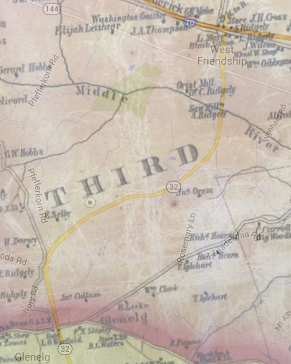
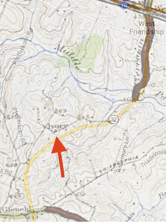
The map below is an overlay of the "current map" above and one from 1860 (Martenet's Map of Howard County, Maryland : drawn entirely from actual surveys) that shows the former homesteads of several families. It shows that the area that is now Fox Valley once belonged to E. (Enoch) Selby (b.1818- d.1899).
|
Enoch Selby
It is currently unclear when or how the property changed hands from the Dorseys to the Selbys. However, there were several marriages between Dorseys and Selbys throughout the years.
Per the book "The founders of Anne Arundel and Howard Counties, Maryland" we learn that: "North of Glenelg, near Ivory Post-office is the estate of the late Enoch Selby, near which was built, in 1750, "The Chapel of Ease." Mr. Selby's homestead was formerly Mr. Peter Barnes', one of the vestry of that Chapel of Ease." |
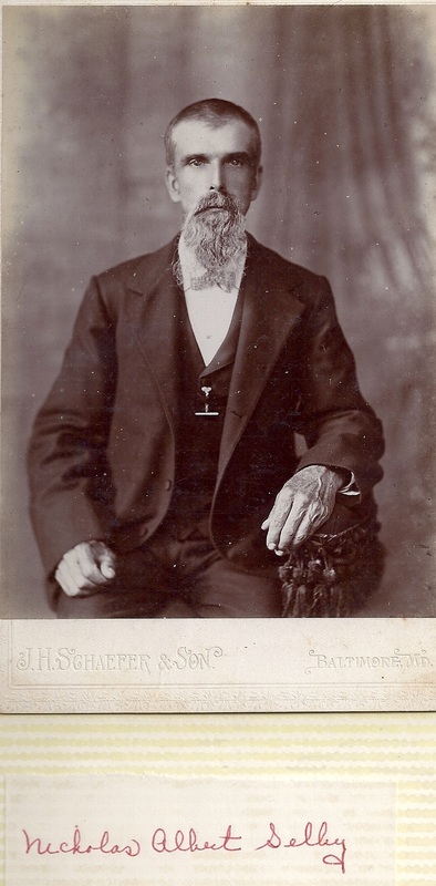
Nicholas and John Selby
|
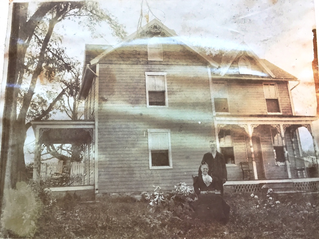
Home of Nicholas Selby and his wife Frances E. in front of their home, somewhere in what is now Fox Valley.
Enoch's son Nicholas Selby (1839-1917) then lived on this land. Nicholas had a daughter Ada (1865-1924) who married William Sheppard (1857-1925), the first and only postmaster of Ivory, MD. As you will see based on the map below, William also lived on this land.
One of Enoch's other sons was John Selby (1848-1926), and his name shows up on title searches from homes in Fox Valley. His wife was Amanda Adeline (Addie) Selby (formerly Day) (1856-1936). Her name also shows up on titles searches from homes in Fox Valley. "The late Mr. Enoch Selby, who built upon the historic estate of " Dorsey's Grove, " is now represented by Mr. John Selby, of the School Board. He has also made handsome improvements in Howard. His estate is near Glenelg. " (from the book "The founders of Anne Arundel and Howard Counties, Maryland") |
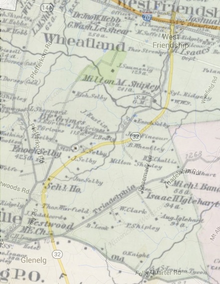
This map is an overlay of our "current map" and the map "From Baltimore and Howard County 1878 published by G. M. Hopkins in 1878". Here you can see by our marker at the intersection of Fox Valley Drive and West Ivory Road the location of a "store". This is very likely to be the store of William Sheppard that eventually becomes the store and post office mentioned below (the post office opens 9 years later). You can also see the home of N. (Nicholas) Selby and J. (John) Selby, both Enoch's sons. Enoch's property is on the SW of our neighborhood land it seems to be close to the entrance to our neighborhood off of Pfefferkorn Rad, and there is a note that he has 425 acres.
Also on the land that is now Fox Valley are the names Thom (Thomas) Grimes (with 115 acres), J. Rustin, P Bodly, and possibly T. Selby whose dot appears to be just at the end of what is now Velvet Valley Drive.
Also on the land that is now Fox Valley are the names Thom (Thomas) Grimes (with 115 acres), J. Rustin, P Bodly, and possibly T. Selby whose dot appears to be just at the end of what is now Velvet Valley Drive.
Ivory, Maryland
From this map we see that the town called "Ivory" is centered directly on our mark on the intersection of West Ivory Road and Fox Valley Drive! If you go to google maps and type in "Ivory, MD", it also brings you to this intersection. Wikipedia states under the listing for Ivory, MD that "Ivory is an unincorporated community located at the Northwest tip of Howard County, Maryland. It is located between modern Glenelg, Maryland and West Friendship, Maryland." Research and anecdotal evidence indicates that the Ivory Post Office was located in what is now our neighborhood (probably very close to what is now the intersection of West Ivory Road and Fox Valley Drive). During the period that this post office was in place, all of the surrounding area would have been listed as being located in the town of Ivory, Maryland. A title search of a Fox Valley home also shows William Sheppard having owned his home on the land that is now our neighborhood.
"William W. Sheppard was appointed on May 13 and commissioned on May 20 of 1886 and that he served as Postmaster until the office was discontinued on February 15, 1918. How it got its name, he was wondering what to name the post office, he kept stores also and had lots of boxes of different things sitting in the store, he saw the box of "Ivory Soap" and said to his wife that is going to be the name of the post office "Ivory"". (from the Howard County Historical Society).
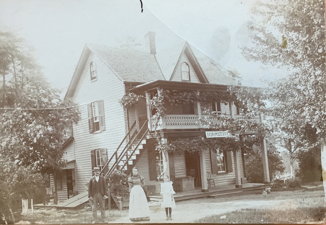
Below is a picture of the Ivory post office with William Sheppard, his wife Ada (Selby) Sheppard, and his daughter Carrie Belle (1890-1973). Carrie Belle Sheppard married Marvin Wilson Day, and was very active in this community and some of the historical information about Ivory at the Howard County Historical Society came from her estate.
* Most of the people mentioned in this article (if not all) are buried in Mountain View Cemetery in Marriottsville.
"William W. Sheppard was appointed on May 13 and commissioned on May 20 of 1886 and that he served as Postmaster until the office was discontinued on February 15, 1918. How it got its name, he was wondering what to name the post office, he kept stores also and had lots of boxes of different things sitting in the store, he saw the box of "Ivory Soap" and said to his wife that is going to be the name of the post office "Ivory"". (from the Howard County Historical Society).
Below is a picture of the Ivory post office with William Sheppard, his wife Ada (Selby) Sheppard, and his daughter Carrie Belle (1890-1973). Carrie Belle Sheppard married Marvin Wilson Day, and was very active in this community and some of the historical information about Ivory at the Howard County Historical Society came from her estate.
* Most of the people mentioned in this article (if not all) are buried in Mountain View Cemetery in Marriottsville.
Ivory Post Office
Information from Neighbor Interviews
Interviews from Neighbors gives us this information:
One story is that at one point the land that is now Fox Valley was all one farm owned by a farmer named Selby. There was a barn on the land that said "Selby Farm 1901". Selby had three kids, and at some point Farmer Selby divided the property that is now Fox Valley between his two daughters. He also gave the property directly across 32 from Fox Valley to a son.
Another story that may tie into the first is that the land that is now Fox Valley Estates was owned by two farmers. One farmer was named Hord and he owned the property that is on the River Valley section. The pond in front of Fox Valley was the Hord’s farm pond. The two farms may have been divided by the old West Ivory Road. The name of the other farm family was Selby.
Selby gave one of his hardest sharecropping workers a quarter acre which is now the small green house that is in the neighborhood. That family tells stories of the kids walking from that house all the way to West Friendship elementary school (the school opened its doors in 1925 for grades 1-9)!
More recently, before the Fox Valley neighborhood was built the only road into this land from 32 was West Ivory Road. Off of West Ivory Road were three homes and two 100 acre farms. Those two big farms are now the two farms that are located to the west of our neighborhood.
The land that is now FV was originally intended to be a golf course with 3 acre lot homes, but that fell through and then it ultimately became the 100+ home neighborhood it is today.
Neighborhood Land Facts:
The land that is now FV was originally intended to be a golf course with 3 acre lot homes, but that fell through and then it ultimately became the 100+ home neighborhood it is today.
Neighborhood Land Facts:
- There used to be a post office off west ivory road but it was eventually torn down (sometime between 1970s and 1990s).
- Prominent last names of former land owners in this neighborhood include: Selby, Shoemaker, Day
- Before the neighborhood was built, around Thanksgiving time a fox hunting club would come through our neighborhood for a formal fox hunt (wearing the red outfits and with a large group of dogs). They gave some neighbors turkeys in gratitude.
- During construction of Fox Valley, the workers came across a rabid fox and promptly pulled out a compound bow went on a truck and chased it through the neighborhood
- One of the homes on West Ivory Road had a windmill for power
